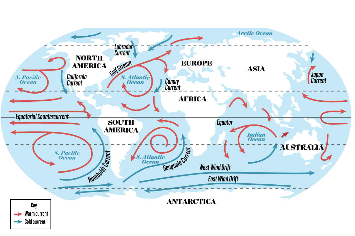
This diagram shows the major currents that affect diving around the world. Over 70 percent of Earth is covered by water. Temperature, tides, water density, wind and Earth’s rotation all have a major effect on how water moves.
How to Check Water Conditions When Planning a Dive
Annie Crawley
Why Read The Water?
Each dive site and destination has a personality that changes depending on the wind, weather, tides and seasons. As you gain dive experience and begin to explore, a baseline understanding of ocean conditions will help you have safe and enjoyable dives. From the moment I show up at a dive site, whether I’m on shore or a boat, I start observing the water.
Many divers rely entirely on travel and tour operators to plan their dives when traveling, but it’s powerful to understand what goes into dive planning for yourself. When you start exploring destinations with maps and charts, you gain a deeper understanding of a region, discover hidden gems and have more fun diving. The following tips will help you read the water and become comfortable with advanced dive planning to make the most of your time blowing bubbles.
Zoom Out
If a site is new to you, start by familiarizing yourself with the area and land characteristics that can provide clues to underwater conditions. Search the dive site or region on Google Earth and on a navigational map. There are many marine navigational maps and nautical charts, including NOAA, C-Map, Navionics/Blue-Chart and many more. Zoom in and explore. On Google Earth or maps you can see details such as rivers feeding into the ocean, remote beaches, rocky shorelines, barrier reefs or outlying islands. Observe the many details as land extends into water and becomes bottom composition.
Are there towns or cities nearby? If so, there could be runoff, sewage or other pollutants entering the water. This could also signal the presence of certain amenities, such as public parking, medical facilities or restrooms. Knowing these things can help you plan your dive day.
Sea lions often congregate in shallow water. In flat seas, you can stay shallow to witness extraordinary animal behavior, but wind or swell could make the dive more dangerous.
Annie Crawley
On nautical charts, you will notice depths and other navigational aids that can help plan distances and depths. Looking at bottom composition and depths gives you an idea of how water flows through a region when the tide changes, which can affect visibility, surf and entry/exit points.
Once you have a good general understanding of the site, head over to an online weather map/tide chart to figure out the directions of predominant wind/weather and other seasonal considerations. Having an arsenal of apps at your fingertips helps you predict dive conditions at any given location. For starters, download the Tide Charts, Windy and Weather apps. The free versions may be all you need, or you may want to purchase and unlock extras. You’ll want to look at a few different things: tides, wind and swell.
Tide Charts
Tides—the rise and fall of the water level at a given beach or bay—are caused by the gravitational pull between Earth, the moon and the sun. The moon phase affects the tide, as does the axis of Earth. The tide changes daily. These changes are predictable and can be found on an online tide chart for any given location.
To use a tide chart, first find one specific to the area you want to visit. Locate the chart for the date and time of day you want to dive. Take a look at the week before and after, paying attention to how much the tide changes daily. In some areas, the tide changes more than 10 to 12 feet between high and low. Because the chart data are an average, a low tide that falls below the average appears as a negative number (-).
Tide illustration
Monica Medina
If beach diving, a negative low tide could mean a very far walk with a camera in tow and/or bad viz. There’s a general rule of thumb divers follow: Slack tide, about an hour before high or low tide, is often the best time to dive with little or no current. Having a baseline understanding of how tides work allows you to layer in local knowledge to specific sites. In some regions, planning dives at slack tide is extremely important. In other locations, you can dive no matter what the tide. This varies within a region as well. You want to really dive into understanding a region by talking to locals, asking questions and researching.
Wind, Weather And Swell
Wind often increases or decreases with a tidal shift. You can listen to the swell report on marine radios or find it on the internet. Swell is caused by wind pushing water from the open ocean toward shore. Strong winds can influence tides. Wind direction and speed can change dive site conditions. When winds blow on or offshore, surface chop forms and potentially creates waves. Strong winds can also create surface currents opposite to the current at depth. Wind is an important factor to consider when dive planning. Depending on the bottom composition, swell or waves created by the wind can alter visibility.
Predominant wind/weather patterns can determine diving conditions. When wind pushes warmer surface water offshore, coastal upwelling brings cold, nutrient-rich water from the deep. This can do one of two things. Colder, nutrient-rich water can appear dirty with bad viz, or colder thermoclines can be crystal clear while warm surface water traps nutrients and sediment. Published scientific papers from a region are a great tool to learn not only about the animals there, but about the predominant wind, weather and currents. The changing Gulf Stream on the east coast of North America affects diving from the Bahamas and Caribbean all the way across the pond to the U.K., Iceland and the Arctic. This current can be completely unpredictable and supersede any tidal event.
Weather, winds and seasons also alter the activities of liveaboard, resort, and dayboat operators. During different seasons, some liveaboard operators move their boats to different locations within a region. In Mexico, operators move between Socorro and the Midriff Islands. In Indonesia, unique itineraries may run on shoulder seasons around changing wind, weather or known oceanic patterns. In the Galapagos, Cocos and Malpelo islands, trade winds affect diving. There are different seasons for pelagic animals in many locations.
Anytime you dive a new and unfamiliar location, participate in PADI Discover Local Diving. You will gain experience with a dive professional and learn how to plan for local conditions and seasons.
Start watching waves and swell from the moment you get to a dive site. When shore diving, it is important to time your entry and exit in the lull of the swell.
Annie Crawley
Research, time watching water, predicting, trial and error, and experience help you understand water conditions and become a better diver. Remember: If you’ve misjudged a tide or there’s bad viz because of weather, wind or bottom composition, you can abort or cancel a dive at any time. Some of the best underwater experiences happen when you explore and plan a dive at a new site. Be safe, know your limitations, and get out and dive!
PRO TIP: Can You Dive During And After Rain? Whether you can dive during or after a rain event will depend on where you are. Rain can change visibility, surface conditions and water bacteria levels. Consider bottom composition, which affects particulates in the water; sources of runoff, which can contaminate the water; and any freshwater entering your dive site, which can decrease visibility. Check local beach alerts for high bacteria levels before getting in. Never dive if storms have made surface conditions dangerous.
Time Your Dive
Tides change throughout the day and vary by location. A flood current is an incoming— or rising—tide. Water moves horizontally toward shore, covering more of the beach. An ebb current is an outgoing tide that pulls water away from the shore, exposing more of the beach. A low tide may mean a longer walk to the water on a shore dive, and a high tide often means better visibility due to increased water volume. Bottom terrain will affect water movement as well. In general, the best time to beach dive is during slack tide, the time between high and low tide, when currents are at their weakest.
Monterey tide chart
Monica Medina
This is an example tide chart for September 7 and 8 in Today’s Tides (LST/LDT) Monterey, California. Here, there are two low and two high tides each day. The chart lists the times of each high/low tide as well as tide height in feet. A low tide that falls below zero (such as the -.71 value on September 7) represents an abnormally low tide. You can use tidal predictions to decide where and when it is safest and most enjoyable to dive.
Original author: Crawley
Stay Informed
When you subscribe to the blog, we will send you an e-mail when there are new updates on the site so you wouldn't miss them.